Telangana Tourism, History, Art and Culture with a 360 degree view, covering anything and everything !

Search This Blog

Showing posts with label Tourism. Show all posts

Gunjala Waterfalls

Gunjala Waterfalls is a seasonal waterfall located near Gunjala village, Bheempur Mandal, Adilabad district, Telangana State, India. 

It is on a rainfed Gunjala vagu which joins Penganga river.

Certain seasonal waterfalls (July to September) that live for a short time during the monsoon have come alive. Thanks to the torrential rains. For instance, scenic Darloddi waterfall, a series of five waterfalls in Khandal village, another at Lohara in Adilabad Rural mandal, Gunjala waterfall in Tamsi mandal, Peddagundam in Echoda mandal of Adilabad district are attracting nature lovers 

It is 21 kms from Adilabad via Ghotkuri to bheempur very first right from bheempur to Gunjala village & the waterfalls is just 3 kms from bheempur.

Time to Visit : July to September

How to reach
Umram railway station is the nearest railway station to Gunjala Waterfalls. It is nearly 9.39 kilometers away from it.


Read More

Adilabad District

Adilabad district is a district located in the northern region of Telangana, India. It is known as the gateway district to South and Central India. The district derives its name from Adilabad, its headquarters town which was named after the ruler of Bijapur, Ali Adil Shah. Historically, Adilabad was known as Edlabad during the rule of Qutub Shahis. It is located about 304 kilometres (189 mi) north of the state capital, Hyderabad, 150 kilometres (93 mi) from Nizamabad and 196 kilometres (122 mi) from Nagpur. 

Originally this was not full fledged district but a sub-district named Sirpur-Tandur which was created in A.D. 1872 with Edlabad (Adilabad), Rajura and Sirpur as its constituent talukas . In 1905, an independent district with headquarters at Adilabad was formed. 

Due to the district’s reorganization in October 2016, Adilabad was divided into four districts: Adilabad, KumramBheem Asifabad district, Mancherial district, and Nirmal district.

Headquarters: Adilabad
Nick Name : White Gold City
Languages: Telugu, Urdu, Marathi, and Lambadi, gondi 
Area: 4,153 sq km 
Population: 7,08,972 which accounts for 3.13% of the total population of the State. 
Literacy Rate: 63.46% 
Block or Mandals: 18 
Villages: 508 
Revenue Divisions : Adilabad and Utnoor
Municipality: 1
One District One Product (ODOP) :  Soya based products- Soya milk, Soya tofu, Soya curd
Rivers : Penganga
Economy : Agriculture, minerals, forests, exports
Minerals : laterite, black granite, coal, manganese, limestone, quartz, clay and road metal.

Geography
Adilabad is 2nd largest district in Telangana region, the first being Mahaboobnagar district.
The city is situated on a well-forested plateau some 2,000 feet (600 metres) high between the Godavari (south) and Penganga (north) rivers. It is an agricultural trade centre, connected with Hyderabad and with Nagpur in Maharashtra state to the north by a national highway. 

The Geo Coordinates of the district are Latitude: 19° 40′ 12.00″ N, Longitude: 78° 31′ 48.00″ E. It is bordered to the north by the Yavatmal district, to the northeast by the Chandrapur district, to the east by the Asifabad district, to the southeast by the Mancherial district, to the south by the Nirmal district, and to the west by the Nanded district of the Maharashtra state.

Economy
Main source of economy in Adilabad is agriculture. Agriculture, minerals, forests, exports - all these join together to make the economy of Adilabad.  Adilabad is coming up at a fast pace economically. However, the district as such is among India's 250 most backward ones and is receiving funds from Backward Regions Grant Fund Programme (BRGF).

Crops produced are jowar, paddy, cotton, wheat, maize, chillies, sugarcane, soya. However, horticulture assumes an important place as it gives supplementary source of income to farmers here. They grow fruits, vegetables and flowers, medicinal plants etc. Mulberry cultivation is also carried out in this region. Cotton cultivation tops the list, though. This is why Adilabad is also known as 'city of cotton'.

Another crop grown in Adilabad is ground nut. Oil is extracted from groundnuts and sold commercially. Agarbatti manufacturing units, wood based industries (furniture making, for instance), leather tanning industries, bakery products and bone mills for exporting various products, Ready made garments (in Adilabad and Mancherial area) and agrobased units like vermiceilli, dal mills, banana chips, fish feeds also contribute to the economy of Adilabad.

Teak and ebony are commercially lumbered in the region.  Agriculture and mining are significant in the regional economy. Rice, sorghum, and wheat rank among the major crops, coal, talc, and limestone are mined. 

Adilabad is famous for its rich cultivation of cotton. Hence, Adilabad is also referred as "White Gold City" is a great place for nature lovers and for history buffs because it is home to thick forests, cascading waterfalls, a diverse population of fauna and also boasts of a long dynastic past.


Food Crops in Adilabad
The soil in this region is black cotton soil which aids the cultivation of food crops as well as non food crops. Cotton is grown in abundance and sold in Maharashtra and other neighbouring states. Other crops grown here include maize, jowar and pulses. Sunflower, soya bean, green gram and black gram are also grown here.

Tourism 
Rural Tourism, Ecotourism and Adventure Tourism
Situated In Mavala Reserved Forest adjoining Adilabad Town along NH-44 spreading in an area of 1000 Acres. Special Attractions : Kids Play Zone, Party Zone, Relaxation AND Rejuvenation Zone, Nature Education Zone, Conservation Zone, Adventure Zone: sky cycling, zipping and rope course, Boating, Nature Walk, Jungle Safari, Bird Watching, Watch Tower, Canopy Walk, Cafeteria, Jungle Shop, Picnic Zone, Pay Homage to Forest Matyrs

Kuntala Waterfalls located near Kuntala Khurd village, Neradigonda mandal
Kuntala Waterfalls is the highest waterfalls in the State with a height of 150 meters offers a spectacular sight particularly when the river is flush with copious inflows. The winter months are ideal for witnessing the waterfalls, as one can also see the river in all its glory. There is an image of Lord Shiva near the water falls known as Someshwara Swami.

Adilabad Khandala Hill Station and Waterfalls
For nature lovers who find Adilabad’s famous waterfalls a little too crowded, the quiet Khandala-Lohara valley encompassing pristine vegetation could serve as a perfect getaway. Located about 25 km from Adilabad district headquarters, it encompasses four little known waterfalls in addition to some vantage points which give a view of the picturesque valley.

Kanaki Waterfalls  located near a small village called Girnoor of the Bazarhatnoor Mandal

Pochera Wateralls located near Pochera Village, Boath Mandal, Adilabad District 

Gayatri Waterfalls a less known water body is situated on Kadam River away from the human eye, waterfalls found its habitat in a remote place inside a deep tropical forest. It is approximately 5 km from Tarnam Khurd village, near Neredigonda Mandal of Adilabad district

Cultural Tourism and Heritage Tourism 
Adilabad, a treasure trove of tribal culture The district has enormous potential for culture tourism thanks to its nearly 3.5 lakh adivasi population who continue to latch on to its glorious traditions. The major tribal groups in the area are the Adivasis: Gonds, Kolams, Pardhans, and Thotis.


Religious Tourism

Shopping Tourism

Music
Kingri also known as Khikri, is a unique string instrument as its three strings and the bowstring are made of horse hair. The younger generation of Pardhan Adivasis, who function as bards of the Gonds preserving their myths and stories through singing, are moving away from tradition

Transportation
NH44 National Highway 44 (NH 44), (previously National Highway 7), is the longest-running major north–south National Highway in India. It starts from Srinagar and terminates in Kanyakumari; the highway passes through the states of Jammu & Kashmir, Punjab, Haryana, Delhi, Uttar Pradesh, Madhya Pradesh, Maharashtra, Telangana, Andhra Pradesh, Karnataka, and Tamil Nadu.

NH-44 starts in Telangana on Krishna River Tribuary Tungabhadra River which is a border with Andhrapradesh, crosses Krishna River, Godavari river and ends in Telangana at Godavari Tributary Penganga River which is a border with Maharashtra.

National Highway 353B, or NH-353B is a national highway in India.It is a spur road of National Highway 53. It traverses the states of Maharashtra and Telangana in India.

South Central Railway zone
Adilabad railway station (station code: ADB) is located at Adilabad town of Adilabad district, in the Indian state of Telangana. It is under the administration of Nanded railway division of South Central Railway zone.

Proposal
Sep 8, 2023 : Patancheruvu (Nagalapalli) to Adilabad New Railway Line FLS Sanctioned at  ₹5,706 crore, 317 km line is likely to connect several important towns like Nirmal, Armoor, Bodhan, Banswada, Sangareddy etc. along the new railway line.

Rivers
The important river that flow through the district is Penganga and its tributaries Sathnala river (Mathadi vagu, Metta vagu), Gomutri vagu, Jella vagu, Nallantiya vagu, Khagdur vagu.

Painganga or Penganga
Origin : Ajantha ranges in Aurangabad district in Maharashtra
Outflow : Penganga converges into Wardha River near a small village called Wadha in Chandrapur taluka of Chandrapur district. Wardha River flows into Pranhita River which is part of Godavari river basin
Acts as a border between Maharashtra and Adilabad district in Telangana.
Telangana Start : Guledi, Tamsi Mandal, Adilabad district
Telangana End : Mangrool, Bela Mandal, Adilabad district 

Pengana tributaries in Telangana
  1. Gomutri Vagu joins  Penganga River near Gomutri, Tamsi Mandal, Adilabad district, Telangana State, India
  2. Jella Vagu joins Penganga River near Wadoor, Bheempur Mandal, Adilabad district, Telangana State, India
  3. Satnala or Sathnala River joins Penganga River near Pendalwada village, Jainad Mandal in Adilabad District, Adilabad district, Telangana State, India
    1. Mathadi Vagu joins Satnala River near Chanda-T village, Aidilabad Rural Mandal
    2. Metta Vagu joins Sathnala River, near LindaSangvi Village, Adilabad Mandal
  4. Nallantiya Vagu joins Penganga River near Kura Village in Jainad Mandal in Adilabad District of Telangana State
  5. Khuni River joins Penganga on Maharashtra side near Kowtha Village in Mudhole Mandal in Adilabad District
  6. Khagdur Vagu joins Penganga River near Khagdur and Mangrool village, Bela Mandal, Adilabad district.
Major Irrigation Projects
Lower Penganga Project is an Interstate Project between the states of Maharashtra and Telangana State on Penganga River, which is a tributary of river Godavari. An understanding was reached between the states of Maharashtra and Andhra Pradesh (Telangana State) on 6th October 1975 to take up Lower Penganga Project as an Inter State joint Project.

The head works are located near Tadsaoli Village in Ghatanji taluk of Yavathmal District in Maharashtra State. It is proposed to utilize 37.55 TMC of water for Maharashtra and 5.12 TMC for Telangana State. The Link Canal which takes off at KM 11.910 from Left Bank Canal runs for a length of about 90Kms to create irrigation potential for about 19,232 Ha (47,520 Acres) in Tribal and backward areas in the 4 mandals, viz. Tamsi, Adilabad, Jainath and Bela covering 89 villages of Adilabad District.

Barrage 1 at Rajapet
Barrage 2 at Rudha Renamed to chanakhakorata barrage 
Barrage 3 at Pimpard

Chanaka Korata barrage 
The barrage is 23 gates is located in Penganga at Chanaka village in Jainath mandal and Korata in Maharashtra. The barrage will irrigate 13,500 acres (5,500 ha) and 51,000 houses in 81 villages in Adilabad district

March 18, 2016 : Maharashtra and Telangana will sign MoUs for construction of five barrages; three barrages on Penganga at Rajapet, Chanaka-Korata and Pinpahad and two barrages on Godavari one at Tummadi Hatti and another at Medigadda. All are inter-state barrages. Out of five barrages, Chanaka-Korata, Tummadi Hatti and Medigadda will be constructed by the Telangana state and the remaining two will be constructed by Maharashtra government.

Jan 13, 2023 : Chanaka-Korata barrage gets environmental clearance
Sep 30, 2023 : Chanaka-korata Irrigation Project Wet Run Successful. The project has a capacity to irrigate over 50,000 acres in Adilabad.

Medium Irrigation Projects
Mathadivagu project is a medium irrigation project proposed across Mathadivagu near Waddai(V),Thamsi (M),Adilabad District under G7 Penganga Sub-Basin. The project envisages to provide Ayacut in 12 villages of Thamsi, Adilabad and Jainath Mandals of Adilabad District.

The project feeds the ayacut of 8500Acres in Thamsi, Adilabad and Jainath of Adilabad District

Villages benifited: Waddadi, Jamidi, Khapparala, Sawergaon, Bandal Nagapur, Bheemsari, Jamdapur, Chanda(T), Bhoraj, Sirsanna, Mallapur, Goatkuri, Dhimma

Status : Operation & Maintenance in Progress.
2006 : Year of Approval. The project was approved by Planning Commission, Government of India vide letter No.20(1)/2006-WR dated 27.6.2006 for an estimated cost of Rs.50.40 cr at 2004-05 price level.

The main components of the project are as under.

(i) Formation of 2.20 km long Earth Bund, with maxiumum height of 17.0 meter
(ii) Construction of 63.25 m long Ogee Spillway and Left Flank Regulator,
(iii) Construction of 13 km long Left Main Canal with CD&CM structures including lining of canal upto 13 km

March 2011 : The project was brought under AIBP during 2006-07 and upto March 2011, irrigation potential of 2024 hectare (5001 acres) is created.

June 1 2013: In case of Mathadi Vagu project, the railway crossing is the only obstacle that had to be tackled as most of the work is complete.Under the project 6,900 acres of land are being irrigated and once the project is completed another 1,600 acres will be irrigated.

Satnala or Sathnala project is a completed medium Irrigation Project across Sathnala river a tributary to Penganga river in Godavari Basin. The scheme is situated near Kanpa (V), Jainath (M) of Adilabad District at a distance of 185 KM from Adilabad town and Railway Station. The project envisages providing Irrigation facility to an extent of 9716 Ha. (24000 Acres) in Khariff comprising I.D. Cotton benfiting 25 villages in the area Jainath, Bela (M), Adilabad mandals.

Status : Operation & Maintenance in Progress
Started : 1977 
1986 : Partially Completed and was launched by the then Chief Minister N T Rama Rao irrigating 5000 acres.
2009 : The State government in 2009 had released Rs 43 crore for the construction of the two canals under the project to be completed in 32 months.The left canal was to begin from Kura to Deepaiguda villages and the right canal was to pass through Balapur and Akurla villages. With their work remaining incomplete, the digging of 18 mini-canals is going on at a snail’s pace.
Mar 9, 2015 : Two canals—the right and the left—were proposed. They remain incomplete even to this day, resulting in supply of irrigation water only to 5,000 acres. 

2018 Proposals
Kupti Project
Construction of Kupti multipurpose project near Kupti village in Neredigonda mandal in Adilabad district at an estimated cost of Rs 870 crore for the SSR 2017-18 to store 5.30 tmc ft of water for supplementation of the Kadam Reservoir. After a detailed investigation, the location of Kupti near National Highway-44 has been proposed to construction of the multipurpose project for the storage of 5.32 tmc ft with full reservoir level of 394 metre.

Pippalkoti barrage
Construction of reservoir with a storage capacity of 1.42 tmc ft at a cost of Rs 369 crore at Pippalkoti 

Gomutri Vagu Project
Gomutri with a storage capacity of 0.7 tmc will be taken up at an estimated cost of `215 crore.

Mountains
The Nirmal or Mahbub ghat is highest peak in Sahyadri parvat or Satnala range in Adilabad district. It is 264 metres (866 feet) high.

Forest
Adilabad has largest area under forest, followed by Khammam. However, in terms of percentage area under forest, Khammam stands first with 48.9 percent of total geographical area under forests, followed by Adilabad with 44.9 percent and Warangal with 28.88 percent.
Dry deciduous forests are important source of forest fuel and timber. Beedi leaves, bamboo and teak are found in these forests.
Blocks : Satnala, Mavala, Yapalguda I, Yapalguda II, Malkapur, Harkai, Dedra, 

Sacred Groves
  1. Adilabad Dankanapally Sacred Grove
  2. Adilabad Jainath Sacred Grove
  3. Adilabad Keslapur Sacred Grove
  4. Adilabad Kunthala Waterfalls Sacred Grove
  5. Adilabad Mahagoan Sacred Grove
  6. Adilabad Narnoor Sacred Grove
  7. Adilabad Pochara Falls Sacred Grove
  8. Adilabad Sadalpur Sacred Grove
  9. Adilabad Sirichelma Sacred Grove
  10. Adilabad Tangri Madra Sacred Grove
  11. Adilabad Yekantapur Sacred Grove
Climate and Rainfall
The climate of the district is characterized by hot summer and in generally dry except during the south-west monsoon season. The year may be divided into four seasons. The cold season from December to February is followed by the summer season from March to May. The period from june to september constitute the south west monsoon season, while October and November from the post monsoon season .

The rainfall in the district, in general increases from the south-west towards the north east. About 85% of annual rainfall is received during the south-west monsoon season. July being the peak rainy month. The variation in the Annual rainfall from year is not large. The normal Annual rainfall of the district is 1044.5mm .

There is a meterological obervatory, station at headquarters Adilabad. The cold weather commences towards the end of November when the temperature begins to fall rapidly. December is generally the coldest month, with the mean daily maximum temprature at about 29 C and the mininum daily is 15 C .

The relative humidities are high generally during the south-west monsoon season. The air is generally dry during the rest of the year, the district part of the year being the summer season when the humidity in the afternoon is 25% .

During the south-west monsoon season the sky is heavily clouded. There is rapid decrease of cloudings the post-monsoon season. In the rest year the sky is mostly clear of light clouded .

Winds are light to moderate with some strengthening in the period from May to August. During the post-monsoon and cold season, winds blow mostly from the east or north-east. By March, south westerlies and westerlies start blowing and continue during the rest of summer. The sought west monsoon season winds are mostly from directions between south-west and north west

Soil
Red and black soil are both found in Adilabad district though black soil predominates, accounting for almost 72% of the soil in the district. The mineral resources are mainly limestone and manganese ore .

District Composition
Area, Population and Other related characteristics

The district comprises an area of 4,153 square kilometres (1,603 sq mi).with a density of population of 170 persons per sq.km .There are 508 villages exist in Adilabad district.

As per 2011 census, the total population of the district is 7,08,972. It accounts for 2.01 percent of the total population of the state. The male population of the district is 3,56,407 and this forms 50.27% of the district and 2.02 percent of the state male population. Similarly the female population of the district is 3,52,565 and this form 49.73% of the district and 2.02 % of the state female population.

As per the latest 2011 census, the rural population of the district is 541226 which constitutes 76.34% of the district population and 2.52% to total of state rural population. Similarly the urban population of the district spread in 1 town is 1,67,746 constituting 23.66% of the district population at 1.23% of the state urban population.

As per 2011 census, the scheduled caste population of the district is 99,422 which is 14.02 % of the district population and 1.82% of the state scheduled caste population. Similarly the Scheduled Tribe population of the district is 2,24,622 which accounts for 31.68% of the district at 7.06% of the state scheduled tribe population.

The density of population of the district according to 2011 census is 170 persons per sq.km as against 312 persons per sq.km for the state. The literacy rate of the district is 63.46% as against 66.54% of the state literacy rate. The sex ratio of the district is 989 females per 1000 males as against 988 of the state

The district was for long not a homogenius unit and its component parts were ruled at different periods by nasties namely, the Mauryas, Staavahanas, Vakatakas, Chaludyasof Badami, Rashtrakututs, Chalukyas of Kalyani, Mughals, Bhosle Rajes of Nagpur and Asaf Jahis, besides the Gond Rajas of Sirpur and Chanda. 

Before the 10th century, this town was referred to as Edlawāḍa, i.e. 'Land of Oxen'. 
Later during the rule of Qutub Shahis it was referred to as Edlabad. 
Adilabad derives its name from the erstwhile ruler of Bijapur, Muhammad Yusuf Adil Shah

1158 AD - 1323 AD : Kakatiya Dynasty

c.1323 - 1750 AD : Sirpur Chanda Gond Dynasty

In 1872 it was part of Sirpur Tandur  sub district of Gond Rajas of  Sirpur and Chanda. 

In 1905 it was declared to be an independent district  of Nizam Hyderabad with a prominent headquarters
April 20, 1981 Indervelly or Indravelli massacre

In 2016, it was divided into four districts namely, Adilabad, Nirmal, Asifabad, Mancherial.


Mandals

Adilabad Revenue division
  1. Adilabad (urban) 
  2. Adilabad (rural) 
  3. Mavala
  4. Gudihatnoor
  5. Bazarhatnoor 
  6. Talamadugu
  7. Tamsi 
  8. Bela
  9. Boath 
  10. Jainad
  11. Ichoda 
  12. Neradigonda
  13. Sirikonda 
  14. Bheempur
Utnoor Revenue division
  1. Indervelly
  2. Narnoor
  3. Gadiguda
  4. Utnoor
Education
Average literacy rate of Adilabad city is 78.74 percent of which male and female literacy was 85.84 and 71.46 percent.

Rajiv Gandhi Institute of Medical Sciences, Adilabad

Sports
The youth in Adilabad is immensely talented. The tribal youth too has interest in various sports activities. However, more efforts are required from concerned departments to attract children and youth into sports.

Indira Priyadarshini Stadium
There is a swimming pool too in this stadium which is visited by all. Most of the children come for swimming during the vacations. It serves to rejuvenate them and also is a means of exercise. Monthly fees for this swimming pool is INR 400 for children and INR 500 for Adults. There is a swimming coach here and four life guards. The water in this swimming pool is regularly cleaned and chlorinated.
Swimming Pool Timings: 5.30 P.M. to 9.30 P.M.

Various sports events are held from time to time to encourage youth living in villages. For instance, Panchayat Yuva Kreeda aur Khel Abhiyan (PYKKA) holds such events in Priyadarshini stadium in Adilabad and sports persons from Adilabad and neighbouring places participate. The event is meant for youth below 18 years of age. Once selected at the mandal level, they become eligible to participate at the district level competitions. Weight lifting, athletics, kabaddi and taekwondo events are held during this sports selection in both girls and boys categories.

Mini Stadium (Utnoor)
Sports Complex in Shanti Nagar, Adilabad has a swimming pool, indoor stadium and wooden badminton court.

The District Sports Development Officer
District Sports Authority,
Adilabad - 504 001
Phone: 08742225846
Fax: 08742225848
Mail: dsa.adb@rediffmail.com

Parliament and Assembly Constituencies :
The district shares Adilabad parliamentary constituency and has 2 Assembly Constituencies Adilabad
and Boath (ST) of 119 constituencies in Telangana State.

Adilabad Lok Sabha constituency is one of the 17 Lok Sabha (Lower house of the Parliament) constituencies in the state of Telangana, India. This constituency is reserved for the candidates belonging to the Scheduled Tribes. Assembly Constituencies : Sirpur, Asifabad, Khanapur, Adilabad, Boath, Nirmal and Mudhole 


Helpline
  • Control Room Collectorate : 1800-425-1939
  • State Control Room : 1070
  • Fire : 101
  • Medical Help line : 102 /108
  • Police: 100
  • BSNL Helpline :1503/ 1800-180-1503


https://www.deccanchronicle.com/nation/current-affairs/010418/telangana-government-gives-nod-for-reservoirs-in-kupti.html


Read More

Nirmal Turkam and Venganna Cheruvu

Turkam or Turkan and Venganna Cheruvu is located near Dimmadurthi or Dimmadurthy and Naldhurthi or Naldurti tucked away amidst the dense forests in the Mamada Mandal, Nirmal District, Telanagana State, India.

Turkam Cheruvu and Venganna Cheruvu in the Dimmadurthy Range, considered hidden gems in Nirmal district, are proposed to be developed into eco-tourism attractions.

Turkam Cheruvu is tucked away amidst the dense forests in the district, while Venganna Cheruvu is described as a paradise for bird-watchers with a lot of perches for avifauna.

These two are the largest lakes in the region and they are located in close proximity to Nirmal town so developing them as ecotourism spots will boost the income of the locals.

Turkam Cheruvu is one of the biggest water bodies in the area spread across 55 hectares. It is a perennial water body as it gets water throughout the year from the Saraswathi Canal.

Venganna Cheruvu is spread across 25 hectares and it is home to different species of birds.

Proposal to install bird-watching towers, eco-cottages, night camping and stargazing, boating and kayaking in the lake, floating houses and stone signage along the nature trail without causing much disturbance to the ecosystem. 

Plans to initiate a Jungle Safari along the 10-km stretch by connecting both lakes. The proposal is yet to be approved by the head office.

These activities will provide employment to the locals as they can set up food stalls, work as guides in the safari, manage boats, cottages and other activities.

Unlike lakes, which form by natural processes, reservoirs are created by humans to provide water and hydroelectricity for our own needs.

A pond is a body of water less than 0.5 acres ( 2023.428 square metres) in an area or less than 20 feet (6 meters) in depth. A lake is defined as a body of water bigger than 1 acre (4,000 m²), although size is not a reliable indicator of its water quantity. 1 hectare is 2.471 acres.

August 30, 2022: Nirmal district's 'hidden gems' to become eco-tourism spots in Telangana

Turkan Cheruvu Location
Latitude 19.05143° or 19° 3' 5" north
Longitude 78.56575° or 78° 33' 57" east

From Nirmal take NH 61

Venganna Cheruvu is one of the two water bodies being proposed for development as eco-tourism spots in Nirmal district.

https://www.newindianexpress.com/states/telangana/2022/Aug/30/nirmal-districts-hidden-gems-to-become-eco-tourism-spots-in-telangana-2493249.html
Read More

Cheriyal Rural Tourism

Cheriyal (or Cherial) is a town and a municipality in Siddipet district in the state of Telangana in India  an hour’s drive from Hyderabad and about 85 kms from Warangal city is known for its unique scroll paintings and masks created by artists called Nakashis. This art form is unique to the state of Telangana. 

The name that the art form is known by today, i.e., Cheriyal, is derived from the town it is currently practised in.The practice of the art form is much more limited than it was previously. Initially, these paintings were known as nakash or naqash, which translates to a drawing or a sketch.

Art and tourism often go hand in hand, with art being a popular tourist attraction. The people involved in the creation of these traditional nakash or Cheriyal paintings, are a community known as the Nakashis. Other than this community, there is another important group of individuals associated with this tradition. It is important to note that the actual purpose of these scrolls was to serve as visual aids when a storyteller narrated a particular folklore or mythological story in the form of a song. This community of balladeers is referred to as kaki padagollu. They travel from village to village narrating these stories.

Cheriyal paintings are long narrative scroll paintings that serve as visual aids to a musical storytelling tradition. A conventional Cheriyal scroll is vertical and is divided into different frames, with each frame depicting a scene from the tale that is being presented. Since these scrolls are meant to be rolled when not in use, they are made with fabric. Traditionally, a khadi cloth is used as the base for these paintings.

The paintings, made on khadi cloth treated with tamarind seeds paste, chalk powder, gum and starch, are mostly based only on epic themes (of Ramayana, Mahabharata, Sri Krishna Bhagavatam, Shiva Puranam etc), village life or festivals.

Like all traditional folk art forms, Cheriyal paintings too use only naturally sourced colours. Most of the pigments used in these paintings are mineral based, i.e., they are obtained from coloured stones. These stones are crushed into a fine powder and mixed with a natural binder and water. The natural binder used is gum arabic, locally called tirumani gond. This mixture is prepared with extreme attentiveness to make paint that is of the right saturation and has the ability to stick to the cloth base.

Paintbrushes are the only tools which are used by Cheriyal artists to draw, paint, and add details to their artworks. Traditionally, these paintbrushes were made using squirrel hair because of how fine the artists could paint with them. However, today this practice has been replaced by market-available synthetic brushes.

The main narrative involves scenes from the common rural life such as women performing kitchen chores, men working in fields or experiencing merry, festival settings, etc. The costumes and settings reflect the culture of Telangana. It offers a glimpse into the rich heritage of Telangana and India through art tourism. The colors and details depict mythological stories and daily life events.

Education
In Badampet village of Telangana’s Sangareddy district, NGO Kudali Centre uses a 3ft by 10ft scroll painting in vivid colours to educate farmers about the perils of mono-cropping. Moving away from organic cultivation of food crops to just cotton, the farmers have seen chemical pesticide costs rising through the roof every year. Farmer suicides are common in the area. Kudali uses a Cheriyal (or Cherial) painting made by national award winner artist D Vaikuntam Nakash to educate the illiterate farmers regarding organic farming.

In another part of the state, a microfinance company has put up six Cheriyal scroll paintings in its office to explain loan, digital marketing and other concepts to semi-literate people wanting to better understand microcredit and its uses.

Cheriyal Painting is widely popular due to the unique rural element which renders an aura of exclusivity and charm for the art items. It represents the pride of Telangana, especially the region’s tryst with such rare and unique art forms. 

For Cheriyal paintings, the background colour is mostly red though green or white may be used some times. The colours are derived from natural sources like white from seashells and black from soot. The most used colours are golden yellow, brown, white, green, orange, black and blue.

Vinay says it takes a month to finish a 3ft by 5ft scroll painting where the whole family is involved in painting. It sells for about Rs35,000 while bigger pieces can take about 6 months for completion.

Some Nakashi artisans have started relocating to Hyderabad in search of a better market. The demand is higher in bigger cities of Chennai, Bengaluru and Mumbai. The artisans also have tie-ups with e-tailers like Amazon besides local websites -- Craftiee, Tvami and Kala Chaupaal Trust, which directly purchase products from them.

The artists also participate in exhibitions and sell their products through various handicraft shops in government museums. “During the pandemic the handicraft stores were not functioning, we received most of our orders through social media. On an average, we got ten orders per month which generated around Rs8000,” says Sai Kiran.

The state government has supported these artists by issuing IDs to acknowledged artisans, giving them employment, buying their handicrafts, and offering them projects.

Geographical Indication (GI) tag
Cheriyal scroll painting also received Intellectual Property Rights Protection, commonly called the Geographical Indication (GI) tag in the year 2008. It is a matter of academic interest for painters all over India and the world, who study the art work with attention to detail and efforts are on to preserve this rich tradition for posterity by actively promoting the tradition of Cheriyal Painting.

A slice of Cheriyal is in Rashtrapati Nilayam,” says artist Dhanalakota Saikiran as he walks us through the 163-foot kitchen tunnel at Rashatrapati Nilayam in Hyderabad. Ever since the President’s official winter retreat was thrown open to the public after a makeover, people have been making a beeline to peek into the estate that serves as the Southern sojourn. A covered corridor connecting the kitchen and dining hall, is now resplendent with murals, masks, and animal heads in the Telangana folk art form of Cheriyal.

With changing times, the popularity of Cheriyal scrolls and the accompanying musical narrative tradition faced a decline. To sustain themselves, these artists have adapted themselves to the changing needs and tastes. Today, the size of these scrolls has been minimised and the number of frames per painting has been decreased too. This is because these paintings are now used more as decorative pieces in households, rather than as storytelling aids.

Cheriyal masks are made of sawdust and fine powder of tamarind seeds. Ganesh, another Cheriyal artist, says it takes six days to prepare these masks which travel hundreds of miles to beautify the corridors of huge mansions. His wife is also actively involved in the craft much like other women of the Nakashi community.

Creating these masks requires patience and attention to detail. Various clay or cement molds are prepared in advance to hasten the molding process.

A fine powder of tamarind seeds, river shells, or coconut shells is boiled in hot water. After an hour, the mixture is collected in a dish, mixed with sawdust, and neatly kneaded into dough.

This dough is then spread evenly onto the desired mold before other facial features are added to the light brown base structure. Sculpting the nose, eyes, and lips requires close attention.

The structure is dried until it becomes rock hard. Upon drying the base structure is smoothened using sandpaper and a thin cotton fabric is spread out on the entire surface of the mask.

A fine paste of rice starch, white clay, and tree lack is evenly applied over the cotton fabric. The paste leaves the surface bright white on drying thereby readying it for color application.

Bright colors like red, yellow, green, blue, white, are used for the base coat. Further detailing of eyes, lips, and ornaments are done using a brush made from squirrel hair. Lastly, varnish is applied to enhance durability.

The seven Nakashi families of Cheriyal create around 250 masks a month.

The process is quicker during summers while it takes these longer to dry during winter and monsoons. If not dried properly fungus can surface due to the presence of tamarind paste.

"We have 20-25 different molds which are used to make faces of mythological characters like kings, queens, village women, Ardhnareshwara, Ganesha, Rama, Sita, Hanuman," says Ganesh.

Among these, the masks for Rama, Sita, and Hanuman are high in demand and cost Rs500. The masks are about 3 inches to 12 inches long. 

The smaller masks cost around Rs300 while the bigger ones range between Rs2000 and Rs3000. The price can even go up to Rs6000, depending on the complexity of the piece.

Ganesh and others have also collaborated with government training centers, imparting the knowledge of mask-making to the younger generation. He has been actively training young students for two years with the help of the state government in an attempt to promote this art form.

Cheriyal masks were used by villagers of the region during festivals to honor the local Goddesses. Dancers wore these masks as a mark of respect for the deities. Gradually, they became popular and people started using them for home decor.

"Cheriyal masks have a national as well as an international appeal but there are only a handful of people who have mastered this art. It will empower women, and they can easily make around Rs20,000 by making the masks from the comfort of their homes," says Ganesh. He gives a daily wage of Rs300 to workers who work at his workshop.

The stories of ancestors beyond what granny knew or could remember, stories of heroes that made them proud, stories that they would sleep with and dream about. Today, the Kunapulis were coming to perform Markandeya Puranam for the Padmasalis and the show will go on anywhere from 3 nights to 20 nights. Later, the Dakkalis will come to perform Jamba Puranam for the Madigas and this cycle of performances will continue till genealogies of 7 local castes (the barber, toddy tapper, washerman, fisherman, leather worker, weaver and farmer) have been recited by bards from their sub-caste.

A non-descript village like any other in rural India and crowded with houses that has pretty wooden doors, Cheriyal is easy to find but not the Nakaashs. It took a lot of asking around and negotiating through narrow streets where one led to the other like a never ending maze to finally reach the humble house of an artist. Once inside his living room cum showroom cum godown, Mallesham carefully unwrapped the colourful frames of Cheriyal paintings depicting both the deities and the everyday life of people in the region.

Environmentally Friendly 
The stunning attraction of Cheriyal scrolls is due to their wholly environmentally friendly and sustainable components. The narrative is typically depicted in a sequence of horizontal panels. The flower border in the middle and resembles modern comic strips divide them. The scrolls are typically created in a vertical arrangement. The scrolls were frequently shown by hanging them from a tree and revealing them panel by panel as the events were narrated. Such type was most common during the nineteenth and twentieth centuries.

The process of creating ancient Cheriyal paintings was entirely natural in antiquity. Everything from the brush to the canvas or linen to the paints was manufactured from natural materials. The distinctive Cheriyal masks are fashioned from tamarind and sawdust, which are then dried into clay. Without using any moulds, craftsmen meticulously hand-cast the features, such as eyes, lips, and nose.

The processes still remain the same wherein the canvas is prepared after coating and drying a handwoven cloth (mostly khadi cotton) with boiled rice starch, white clay, gum and boiled tamarind seed paste in layers. Every coating is allowed to dry thoroughly before the next is applied. When the canvas is dry and hard, an outline of the painting is made using indigo on an essentially red background and later colours are filled in. The colours used are natural derived mostly from seeds, flowers and stones like black from lamp soot mixed with gum from the thirumany tree, white from sea shells, red from tamarind seeds, brown from geru. The frame is marked by a floral border indicating the end of a scene on a scroll. Now, it is merely ornamentation as the scrolls have miniaturized into frames meant for hanging on a wall. Yet the scenes retain a strong local flavor as it follows the tradition of oral story telling.

History
The origin of Cheriyal Paintings can be traced back to 5,000 years. This style of artwork uses these paintings as a visual aid to recite tales from 'Ramayana' and 'Mahabharata'. Also Read - Drivers of all VIP vehicles must undergo driving tests, says Ponnam Employing traditional techniques, Cheriyal paintings are created on cloth that might run to metres in length. In the present day, Cheriyal paintings are done in a variety of goods such as masks, marriage gifts, jewellery boxes, brass paintings and greeting cards. 

The story tellers would go to the ‘Nakaashs’ and recite their story that would be painted scene by scene, character by character onto a scroll. 

Employing traditional techniques, Cheriyal paintings are created on cloth that might run to metres in length. In the present day, Cheriyal paintings are done in a variety of goods such as masks, marriage gifts, jewellery boxes, brass paintings and greeting cards.

The traditions surrounding Cheriyal scroll paintings have contributed massively to our cultural memory. Hence, it is an art form that has garnered much fame, and rightfully so. People have been making these paintings for a very long time, creating both art and tourism. 

Some think they began in the 5th century. The earliest reference to this tradition dates back to the 12th century; the Kakatiya times where Ekamranatha in his literary text Pratapa Charitram indicates the presence of 1500 painter families living in and around Warangal. 

Even today the Nakaashs live in Cheriyal, a small village with winding alleys about 85 kms from Warangal city.


Read More

Telangana Tourism

Tourism in Telangana has very rich potential with its ancient history, art and culture, evidence of human habitation dating back to the Neolithic era. 

Telangana’s rich cultural heritage, history and topography have endowed the state with a variety of tourist destinations, from waterfalls and hills to temples and forts. With affordable travel and stay, a unique albeit delicious blend of South-indian and Nizami cuisines, amusement and adventure parks, hospitality, lakes, historical attractions and medical tourism, Telangana has a little something for every visitor.

The State also won four National Tourism Awards in the four categories of Best State (Comprehensive Development of Tourism), Best Golf Course (Hyderabad Gold Club), Best Railway Station (Secunderabad Railway Station) and Best Medical Tourism Facility (Apollo Hospitals) in 2022.

From its ancient archaeological sites to its magnificent monuments, Telangana offers a fascinating journey through time.Telangana is home to numerous archaeological sites that provide a glimpse into its ancient past.

UNESCO world heritage site
The Rudreshwara temple also popularly known as the Ramappa temple (built during the Kakatiya period) situated in the Mulugu district of the state was declared a UNESCO world heritage site in June 2021. 

Rural Tourism
Telangana has a tremendous potential for Rural Tourism and is a fascinating canvas of myriad colours, cultures and customs. Handicrafts represent perhaps the oldest traditions of living culture and Telangana has some of the richest sources of handicrafts. The rural handicrafts provide a valuable contribution to Telangana’s tourism product. 

Rural Tourism projects identified in Telangana, by the Ministry of Tourism, Govt. of India are Pochampally Rural Tourism Project, Nalgonda District, Nirmal Rural Tourism project, Adilabad, Cheriyal Rural Tourism Project, Warangal and Pembarthi Rural Tourism Project Warangal.

Best world tourism villages by UNWTO (United Nations World Tourism Organisation) 
 Pochampally, a village located in the Yadadri Bhuvanagiri district, best known for its beautifully woven ‘Ikat’ sarees was awarded as ‘one of the best world tourism villages’ by the UNWTO (United Nations World Tourism Organisation) in November 2021. 

National Best Rural Tourism Centres for 2023
Pemberthi, located in Jangaon district, is renowned for its exquisite handicrafts.
Chandlapur, situated in Siddipet district, is celebrated for producing prestigious Gollabhama sarees and its scenic charm, nestled amidst the Ranganayaka hills.

Adventure Tourism has lot of potential in Telangana, with many waterfalls and forest area with Rock Climbing, Camping and Trekking.

Rock climbing in Bhongir is quite popular near to hyderabad.

The state is known for its vibrant cultural traditions, celebrated through music, dance, and festivals. Explore the folk dances of Telangana, such as Perini Sivatandavam, Bathukamma, and Lambadi, which reflect the essence of the region. Immerse yourself in the melodious strains of Telangana’s folk music, with its unique instruments and soul-stirring lyrics.

Telangana’s Living Traditions: While exploring Telangana’s heritage, encounter its living traditions that have stood the test of time. Witness the age-old craft of Bidriware, known for its intricate silver inlay work on metalware. Explore the handloom clusters of Pochampally and Gadwal, where master weavers create exquisite silk and cotton sarees. Engage with the skilled artisans who continue to preserve and promote these traditional crafts.

Ecotourism in Telangana is increasing with its green zone and hilly areas with very old hills and caves. Hiking, birdwatching, wildlife viewing, Water adventures, caves and climbing are some of the activities.

Religious Tourism in Telangana with its diverse culture has something for everyone, with its very old Hindu Temples, Jain Temples, Buddhist Temples, Gurudwaras, Churches and Mosques 
 
Shopping Tourism in Telangana has not been tapped much, has very old artisans making things generation after generation. We need to market the goods. 

Culinary Tourism 
Telangana is popularly known for its variety of food. Increase in the number of food bloggers is definitely indicative of the diversity of cuisine available in the state. The state offers different kinds of street food experiences, delicacies from different districts of the state and not to mention the ‘biryani capital’ of the country, Hyderabad.

Hyderabad, known for its Biryani and its incredible range of food was designated by UNESCO as a ‘creative city of gastronomy’ in 2019. Hyderabad’s Haleem first received the Geographical Indicator (G.I) tag in 2010 which made Haleem, the first meat based dish from India to win the honour. The tag was renewed again in 2022. Haleem also won the ‘most popular G.I food’ beating out 17 other dishes in the country. These accolades are testament to the rich culinary experience the state has to offer. Other than these, Telangana has an abundant variety of foods for foodies of different kinds.

Medical Tourism
Hyderabad, the country’s healthcare capital. Hyderabad is one of the most imporatnt places for medical treatment & patients not only from India but from abroad also visit Hyderabad for treatment.

Best Medical Tourism Facility (Apollo Hospitals) in 2022.


Read More

Khajaguda Hills

Khajaguda Hills located in Khajaguda also known as Khojaguda is a Village in Serlingampally Mandal, Rangareddy district, Telangana State, India. It is part of the old city of Hyderabad. The site is a popular spot for outdoor activities, such as hiking and bouldering.

Khajaguda hills is one of the most popular weekend spots near Hyderabad. It is known for its magnificent viewpoint of Golconda and Durgam Cheruvu, peacocks, and naturally formed rocks and boulders that facilitate thrilling activities like rappelling.

The hilltop offers a breathtaking view of the city below with its lush green surroundings. It is a perfect place to spend some quality time with your friends or family away from the hustle and bustle of the city life. The area also has several other attractions such as temples and caves that make it an ideal spot for nature lovers. With its pristine beauty and adventure activities, Khajaguda hills has become one of the most sought-after weekend spots in Hyderabad.

Hidden away from all the hustle and bustle of city life, these majestic hills offer breathtaking views and a chance to explore a fascinating part of history. Get up close and personal with nature while you learn about its ancient origins!

One of the finest prehistoric heritage sites, the Khajaguda Rock Formation is spread across 180 acres in Nanakramguda in Hyderabad, Telangana

The Fakhruddin Gutta granite rock formations, popularly known as the Khajaguda Hills, are a geological marvel that are estimated to be around 2.5 billion years old! It is a part of the Deccan Plateau and is also one of the oldest rock formations in India.

Telangana's Khajaguda Rock Formation is as old as the Earth's crust!
Around 4.4 billion years ago, the formation of Earth’s crust took place and soon after that, the formation of what we know today as the Khajaguda Rock Formation started. One of the oldest forms of rocks, these are formed of gneissic granite, one of the hardest forms of rocks on earth.

Usually, newer rocks form over these tough base rocks over a period of time. But, in Khajaguda, this didn’t happen and the billion years old rocks stand exposed till date, albeit in a poor condition.

As per the geologists researching the area, there are boulders, castle koppies, nubbins, inselberg, peneplains, kluftkarren, corestones, pans, fracture valley, runnels, balancing rocks, pseudobedding, pits, tafoni, plinths, rock doughnuts, caves, splits and wedges, and chaos – all these are different kinds of rock formations. What a field day it would be to get a chance to explore the site with researchers!. While we can’t say much about exploring the area with geologists, what you can certainly do is hike the area and take in the moment as you stand in the presence of something that is as old as our planet!

Khajaguda Lake, also known as Bhagirathamma Cheruvu was built during the reign of 6th Nizam Nawab Mahboob Ali Khan in 1897 and is spread over an impressive 618-acre. Surrounded by lush greenery and open skies, it provides a serene setting for visitors to sit back, relax and take in the natural beauty. Not only that, it also supplied water to 900 acres of Ayakattu in Kamareddy, Sarampally and Narsampally areas!

The tomb of Saint Hazrat Baba Fakhruddin Aulia — spiritual mentor of Ala-ud-Din Bahman Shah (founder of the Bahmani Kingdom) who was buried here in 1353 AD

800-year-old Annatha Padmanabha Swamy Temple and a cave where the revered saint, Meher Baba had meditated are situated on Khajaguda Hills.

The caves in the area are another interesting thing to explore. Remember how we said earlier that these rocks are the hardest forms of granite? Cave formation would be the last thing to expect of these hard rocks. But they are there, much to the surprise of geologists. Something rare, is what they say about these Khajaguda caves.

The forest patch at Khajaguda is home to several species of plants, that just like the rock formations, are difficult to find near Hyderabad. The Nyctanthes arbor-tristis, popularly known as the parijata or the night-flowering jasmine, is found in abundance at Khajaguda (there are three national parks around Hyderabad and the Parijata cannot be found in any of these three parks).

The other important plant species at Khajaguda is the Helicteres isora, also known as the Indian Screw Tree. These trees have not been recorded by the Botanical Survey of India in any areas around Hyderabad. Khajaguda is the only place where these can be found.

Best Time to visit
Sunrise and Sunset. Sunrise as you can enjoy the breathtaking view of the sun rising above the hills with the rays piercing through the morning clouds Relish Sunset at the summit . Sunset point for photoshoot in Hyderabad

Monsoons are the time when nature is at its best. Mercury levels having dropped a few notches and the lush greenery make it the best time to visit any tourist destination. One such place, whose beauty is heightened in the monsoon, is the Khajaguda Hills in Hyderabad. 

How to get there
There are two ways to reach this place: take the ORR and drive to the bottom of the hill or reach Khajaguda village and follow the path that leads to the hills. The trek to the top of the hills is easy and does not require professional hiking gear.

Use Google Maps, not Apple. Map directly to Delhi Public School. If you map to the exact location, you may be brought in the back way, which is not a way at all. Take Old Mumbai Highway or Outer Ring Road to Khajaguda Road. Follow it to Lanco Hills Road (large silver structures on this intersection). Turn onto Lanco Hills Road. When the divided road ends, take the second right (the first is immediately at the ending of the division). After taking this right, take the first left. The road turns dirt here and heads up the hill. The road is rough but passable. If you wish to walk from here, it is maybe a 10-20 minute approach up hill. If you follow the road (by car or foot) stay right at the fork. You'll reach the top and there is an open area. Park here. The approach from here varies, but should be no more than 10 minutes (to the farthest rocks).


Improvements
In October 2023, Hyderabad Metropolitan Development Authority (HMDA) started work to fence the 2.5 billion-year-old Khajaguda rock formations and limiting access to motorists, visitors, an effort to keep the encroachers at bay.

Outer Ring Road -Lanco Hills link road is under construction as part of Corridor 39B. This 3.89 km long link road is constructed alongside the Khajaguda Heritage Rock Formation.


https://timesofindia.indiatimes.com/travel/destinations/telanganas-khajaguda-rock-formation-is-as-old-as-the-earths-crust/articleshow/95272121.cms


Read More

Chandlapur Rural Tourism

Chandlapur is a village in Chinna Koduru mandal, Siddipet district, Telangana State, India. Located at a latitude of 17.72692 and a longitude of 78.00892, is renowned for its rich heritage of producing intricate handlooms, particularly Gollabama Sarees.

Weaving has become the primary occupation of many villagers, with these exquisite sarees finding recognition both nationally and internationally. The village boasts a cultural legacy rooted in the traditional art of handloom weaving, preserving ancient techniques and utilizing traditional materials.

The primary theme of tourism in Chandlapur is centered around promoting and showcasing its exceptional Handloom Craftsmanship, with a particular focus on Gollabama Sarees.

Chandlapur has been recognized as Best Tourism Village 2023 in Bronze category.

Chandlapur stands as a living testament to the timeless art of handloom weaving and this enchanting village is a treasure trove of intricate craftsmanship and cultural heritage.

Chandlapur's theme is a symphony of threads and traditions, where every weave tells a story. At its heart lies the exquisite Gollabama Sarees, a testament to the villagers' unwavering dedication to preserving ancient weaving techniques.

Village mesmerizes by its rhythmic clatter of looms, the skilled hands of local artisans, and the vibrant hues of their creations. Beyond the looms, the village also boasts a variety of attractions, from the historic Ranganayakaswami Temple to the tranquil Ranganayaka Sagar Reservoir.

Chandlapur actively participates in the Telangana Harita Haram initiative, passionately engaging in plantation drives and composting to enhance greenery and combat environmental pollution.

Promotion of Handloom Weaving
The village actively promotes and conserves its traditional handloom weaving techniques, with a particular emphasis on Gollabama Sarees.

Development of Ranganayaka Sagar Reservoir
Chandlapur, in cooperation with the Telangana Tourism Department, is developing the Ranganayaka Sagar Reservoir as a significant tourism destination.

Environmental Conservation
Chandlapur participates in the Telangana Harita Haram initiative, focusing on increasing greenery and reducing environmental pollution through plantation drives and composting.

Economic Growth
The tourism ecosystem built around handloom weaving and cultural attractions has contributed to economic growth, generating income for local artisans and service providers.

Employment
The tourism sector has provided both direct and indirect employment opportunities, benefitting the local community, including weavers, craftsmen, and service providers.

Cultural Preservation
Initiatives to promote handloom weaving have helped preserve and promote the village's cultural heritage, ensuring the continuity of traditional crafts.

Environmental Conservation
Measures to ban single-use plastic, increase greenery, and promote sustainable practices have contributed to environmental conservation and awareness.


Read More

Kapuram Fort

Kapuram Fort or Kapuram Khilla is located in Kapuram village, Malhar Rao mandal in Jayashankar Bhupalpally district, Telangana State, India.

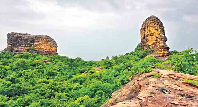
Situated in the dense forest about 42 km away from the district headquarters, Kapuram Guttalu (hillocks) also known as Kapuram Khilla is calling for the attention of tourism officials.

While there are three hillocks with a height ranging between 200 to 250 feet, people can scale only one of them with difficulty, for a jaw-dropping experience. The hillocks resemble landscapes of Utah, Colorado, in the USA.

From October to June, people can visit these hillocks. But one should take the help of local residents (Nayakaopodu tribals) during this expedition. The hillocks are not accessible during the monsoon season,” he said, adding that it was not safe to visit the place without the help of the locals as these hillocks are the habitat of some wild animals like sloth bears and others. A stream also flows adjacent to these hillocks.

According to archaeology enthusiast Aravind Arya Pakide, the hillocks were used as a military base during the reign of the Kakatiyas. “We can see the remnants of the fort on the hillocks,” Aravind said.

The hillocks, which are part of the deciduous scrub forests, are the habitat of 80 species of hawks, eagles apart from rare species of butterflies including Banded peacocks. The place is also known for medicinal plants.

Aravind said that the Kapuram Fort (Khilla) needs to be identified as a historical site and steps must be taken to conserve it besides promoting eco-tourism activities by providing road facilities.

Former DFO K Purushotham, who also worked as the DFO of Bhupalpally district, said that the place was once a habitat of the big cat.

When contacted, Kalyanapu Suman who is the Eco-Tourism manager for erstwhile Warangal district said he had made a presentation at the DTPC on the tourism potential following the directions from the then-District Collector and chairman of DTPC, Mohammad Abdul Azeem, and were chalking out plans to promote eco-tourism activities at the Kapuram hills along with other places including Nainpaka temples, Boggulavagu project and Prathapagiri Fort.


 Call to conserve ancient hillocks in Bhupalpally


https://telanganatoday.com/call-to-conserve-ancient-hillocks-in-bhupalpally


Read More

Penjerla Sri Anantha Padmanabha Swamy Temple

Penjerla Swayambhu Sri Anantha Padmanabha Swamy is a Hindu Temple is located in Penjerla village, Kothur Mandal, Ranaga Reddy district, Telangana State, India.

Svayambhu or Swayambhu is a Sanskrit word that means "self-born", "self-manifested", "self-existing", or "that that is created by its own accord". 

Timings : 7 AM to 1 PM and 4 PM to 7 P

Address
4836+VJG, Penjerla, Shamshabad, Hyderabad

Contact
+91 90106 14354
penjerlasriananthapadmanabha@gmail.com


Read More

Aggalayya Gutta Jain Temple

Aggalayya gutta is located in Hanamakonda, Padmakshi temple road, Hanumakonda district,Telangana state, India. It was also a jain ayurvedic medicine center around 11th century

This Jain site on the Aggalayya gutta has a 30-feet-tall engraved statue of the 16th Jain Tirthankar Shantinatha and a 13-feet-tall statue of 23rd Tirthankar Parshvanatha on a huge boulderstone on a hillock.

The Shantinatha statue is the second tallest Tirthankaras statue in South India after Karnataka’s Bahubali Tirthankara, and the plan is to make it a Jain Vanam. Statue of the Mahavira is also there in a cave on the hillock.

The hillocok was named after, Aggalayya, who constructed a ‘Jinalaya’ that served as a research centre for teaching doctrines of religion, medicine, and surgery.

Aggalayya who was an ayurvedic doctor and researcher of 11th century taught Ayurveda to students at this center. He worked extensively on teaching and propagation of doctrines of religion, medicine, surgery, etc. The Sirur inscription of Medak mentions Aggaalaih as the Chalukya King Jagadekas physician.

Though its is popular as Jain site, none could discover the fact that the hillock was a hub of ayurvedic treatment during 11th century. Some parts of the Gokarnam which is used to store ayurvedic potions and pour into the mouth of the patient, were also found at the site. The hillock was a place of medicinal plants. “I have seen may mortars at various locations, but mortars made on the rock on the Aggalayya Gutta are unique amon them” said Ratnakar Reddy.

Aggalayya gutta also has a lot trees and plants which makes the place breathable

Near Hanumakonda bus station and Chowrastha. Around half Kms. Around 600 steps are there to reach top of the hill . Opens at 9 A.M and closes at 6 P.M

This site is developed under National Heritage City Development and Augmentation Yojana (HRIDAY) scheme by KUDA (Kakatiya Urban Development Authority) in 2017.


Read More

Dulapally Prasanthi Vanam

Dulapally Prasanthi Vanam is located in Dulapally, Quthbullapur Mandal, Medchal-Malkajgiri district, Telangana State, India.

Prasanthi Vanam Park in Dulapally is developed in Dulapalli Reserved Forest area located on Dulapalli – Bahadhurpally Road was once a dump yard which has undergone an incredible transformation. Developed in 25 acres this park is presently filled with medicinal & flower plantations; has a walking track & children play area.

The major species available in the park are Marri, Raavi, Peltophorum, Usiri, Chinta, Bamboo, Nemalinara, Seethaphal etc.

Facilities in prashantavanam park:-
i. Entry plaza developed with the parking facilities.
ii. Long walking track and internal walking pathways are developed in this park
iii. Yoga shed
iv. Gazebo
v. The medicinal plant garden.
vi. Wash Room.
vii. The ticket counter.
viii. The security Room with Office Room
ix. The Children play Area
x. The Open GYM
xi. The artificial sitting benches.

Details
Visting Timings 11.00 AM to 6.00 PM
Visting Ticket Adults Rs.15/-
children Rs.10/-
Walking Timings 5.30 AM to 9.00 AM
Walking Pass Monthly pass : Rs.100/-
6 Months pass : Rs. 400/-
1 Year pass : Rs.800/-
Parking Ticket 2 wheeler : Rs: 5/- for day
4 wheeler : Rs: 10/- for day.
Contact Details Mallikarjun Naik (FRO):9000590369
Holidays All Days Open

The park is around 20 Kms from secunderabad.


Read More

Bhagyanagar Nandanavanam Park

Bhagyanagar Nandanavanam Park is located in Narapally village under Pocharam Municipality in Ghatkesar mandal, Medchal-Malkajgiri District, Telangana State, India.

Bhagyanagar Nandanavanam Park comprises of a buffer zone covering an area of about 84.24 hectares and a conservation zone covering an area of about 116 hectares. 

The Bhagyanagar Nandanavanam is also a deer park. Walking along the pathway, you will find some Peacocks as the park hosts a small peacock sanctuary.

Bhagyanagar Nandanavanam a nature conservation park, has Walking track developed with a length of 4 Kms internal pathways and a Canopy walkway with a length of 200 mts. The park is a visual treat for nature lovers. 

Beyond wonderful walkway you can experience Forest trails at Bhagyanagar Nandanavanam park.

The park has a metal fencing Canopy Walk way of 200 meters laid with strong iron mesh with railings on both sides above 20 feet from the ground and a watchtower to have a good 360 degree view of the complete park from here.
 
The Bhagyanagar Park is ideal for weekend outings, there is a well maintained walkway, green trees and above all, you will get disconnect with urban concrete jungle once you are inside the park.

The park with green walking paths, forest trails, a perfect destination for nature walks, a romantic getaway and space for morning walk and evening walk.

Activities
Canopy Walk, Walking, Kids Play Area, Forest Trails, Bird Watching, Cycling, are some of the activities you can engage here.

Rock Climbing
The outdoors has something more to offer than just physical benefits for children. Cognitive and social/emotional development are impacted, too. Outside, children are more likely to invent natural adventure games. As they do, they're able to express themselves and learn about the world in their own way.

How to Reach
The park is situated at about 25 Km from Hyderabad city towards eastern side, in the Ghatkesar Mandal, on Hyderabad-Warangal road in Narapally, Medchal District.

From Jubilee Hills - 30Kms
From Gachibowli - 40Kms

Timmings
Walkers
5:30AM to 9 AM

Visitors
11 AM to 6.00 PM

Tariff
Audults - ₹15
Children [5-12 Years] - ₹10

Cycling - ₹20 / Hour
Canopy Walk Way - ₹5

Membership
1 Month - ₹100
6 Months - ₹400
1 Year - ₹800


Note: Smoking and Chewing Tobacco is strictly prohibited in Bhagyanagar Nandanavanam Park!

Note: Plastic bags and disposable bottles not allowed.
Read More

Kandlakoya Oxygen Park

Kandlakoya Oxygen Park is located in Kandlakoya Village towards the Outer Ring Road, Medchal Mandal, Medical-Malkajgiri district, Telangana State, India. 

For nature lovers and adventure-seekers, who find peace in exploring green forests and study birds, etc, need not worry about planning their holidays elaborately, as Kandlakoya Oxygen Park, spread in sprawling 75 acres has come up just in city backyard - about 20 km from Paradise Circle and six km from Kompally on the NH44. Hyderabadi's along with family and friends can escape from the concrete jungle and city's hustle bustle to spend time in tranquility whenever they want without any elaborate planning.

The Kandlakoya Oxygen Park is known for its rich biodiversity. It is situated at a high altitude and people go for treks and nature walks here.

The park has a variety of trees, including medicinal plants, and is home to numerous species of birds and butterflies. The park also has a children’s area, a butterfly park and a tree-top walkway. At the oxygen bar of the Kandlakoya Oxygen Park, visitors can breathe in pure oxygen.

The park offers different walking tracks to enjoy the nature at its core. This park gives respite from pollution with a breath of fresh air.

The Oxygen Park has a 2.2 km walking track along the periphery and internal pathways add another 2 km to the walk.

Canopy walk is provided with a length of 260 mtrs, walking on canopy gives visitors a visual treat by watching birds close by and feel the touch of nature.


Activities

Canopy Walk, Walking, Kids Play Area, Forest Trails, Bird Watching, Cycling, Dining in Forest are some of the activities you can engage here.

Walk and jog: The park has a jogging track perfect for walking, jogging, and running. The track is surrounded by greenery.

Take a nature walk: The park has several walking trails that are well-marked.

Bird watching: Peacocks, parakeets and kingfishers are few of the many bird species that are found in the park.

Trekking: The Kandlakoya Oxygen Park has a trekking trail that takes you through the park’s forest area. The trek is moderately challenging.

Cycling: The park has a cycling track that is perfect for cycling enthusiasts. At the park, you can rent bicycles or bring your own.

Picnic: The Kandlakoya Oxygen Park is ideal for a picnic with family and friends. The park has several picnic spots.

Yoga and meditation: The park has a dedicated area for yoga and meditation.

Adventure sports: The park offers adventure sports like ziplining, rock climbing, and rappelling for those seeking an adrenaline rush.


Distance 
Suchitra Circle - 12Kms
Secunderabad : 18 kms
Paradise Circle : 20 kms
Jubilee Hills - 30Kms
Gachibowli - 40Kms

Timmings
Walkers : 5:30AM to 9 AM
Visitors : 6 AM to 6 PM

Tariff
Audults - ₹15
Children [5-12 Years] - ₹10

Walking Membership
1 Month - ₹100
6 Months - ₹400
1 Year - ₹800

Note: Smoking and Chewing Tobacco is strictly prohibited in Kandlakoya Oxygen Park!
Note: Plastic bags and disposable bottles not allowed.

The Kandlakoya oxygen park was inaugurated on March 21, 2018 by former forest minister Devaramane Nath. The park has become the first choice of families keen to spend quality time, especially on weekends.


https://www.thehansindia.com/telangana/kandlakoya-oxygen-park-enjoy-deep-forest-outing-in-citys-backyard-600175

Read More
Telangana360.com. Powered by Blogger.

© Telangana360.com, AllRightsReserved.

Designed by ScreenWritersArena